Latest News
Everyone is familiar with geothermal in our region, from the geysers and pools of Rotorua to Wairakei’s large power stations in Taupō, and the industry in Kawerau. What we are less familiar with is the lower level geothermally influenced Tauranga Geothermal System (TGS).
“The Tauranga Geothermal System (TGS) covers an area of approximately 875 km2 in the Western Bay of Plenty … It is classified as a groundwater system that is warmed by underlying geothermal influences. The groundwater temperatures in this area range from approximately 15°C in the absence of a geothermal influence up to a maximum recorded temperature of 70°C. Approximately 70% of consented wells are shallower than 200 metres and the deepest well is at 916m. (GeoExchange NZ Limited, 2024).
This article is a high-level introduction, more detailed information can be found in the report commissioned by Bay of Plenty Regional Council, undertaken by GeoExchange NZ.
Preliminary Scoping Study: Geoheat Potential of the Tauranga Geothermal System.
The article references work completed through this process but also presentations developed by GeoExchange to help businesses get a better view of the opportunity.
At the end of this article, you will also find a video presentation by GeoExchange.
What is GeoHeat?
‘GeoHeat’ broadly refers to geothermal energy, which is thermal energy extracted from the earth’s crust. Fun fact: ‘geothermal’ is derived from the Greek words geo (Earth) and therme (heat). In New Zealand, geothermal temperatures are typically those greater than 30°C.
Geoheat systems are typically either:
- Direct Use – Systems that use the heat directly like a hot pool.
- Indirect Use – Systems that require a heat pump to modify the source temperature.
Most business and commercial applications will be indirect and therefore require the use of a heat pump to modify the temperature.
The Tauranga Geothermal System (TGS)
The maps below provide two perspectives of the temperatures available over the TGS. The temperatures within the Te Papa Peninsula, Mount Maunganui and Rangiuru are all promising being at the higher end. But of note in the second map is the coverage of 30°C at various depths, which covers a very wide part of the TGS.
Currently the primary users of the TGS are community facilities, tourism, and a smaller amount of private commercial usage. As the TGS is an aquifer, it also has a range of users who are just accessing it for water as opposed to heating/cooling.


For commercial use, GeoExchange illustrated the use of Ground Source Heat Pumps (GSHP). These transfer heat from a source (ground, water, air) to provide heating or cooling. The advantage with a GSHP is they are not influenced by variable air temperatures and are relatively constant, unlike some other sources.
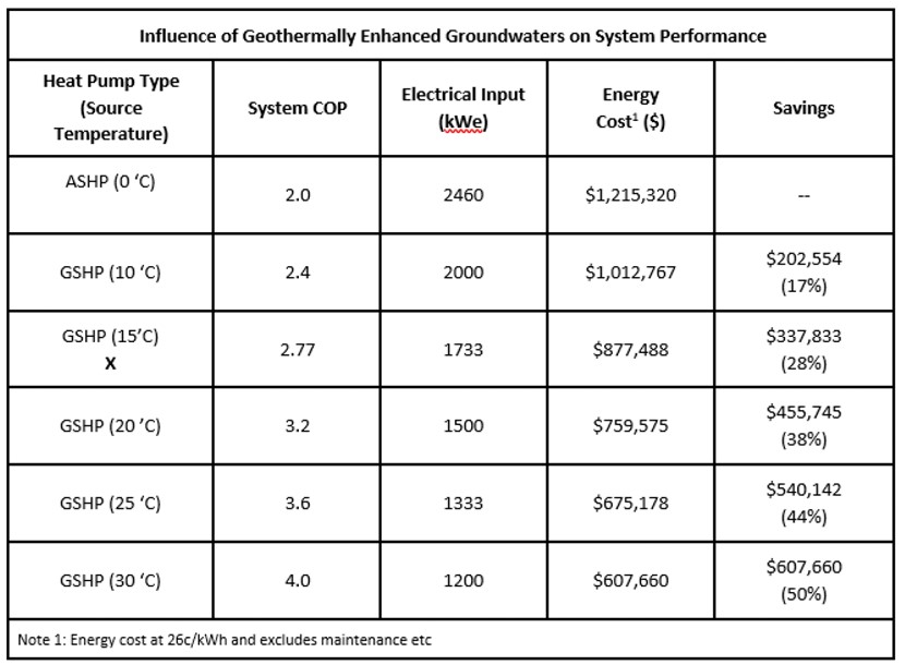
The table below is useful in conjunction with the temperature map. It shows the Coefficient of Performance (COP) relative to the source temperature. The higher the COP, the bigger the savings.

This table provides a view of the relationship between the COP and the possible savings on energy cost which is really useful.

It’s still early days for TGS, in terms of commercial applications, but it looks promising as a tool in the suite of options for the region to decarbonise, and to improve energy resilience with energy that is drawn from within the region.
This connects with Priority One’s Regional Energy Strategy, which is still in development. We expect to consult industry and local government in December, for a release in early 2025.
If you want to learn more, please contact Timothy Allan timothy@priorityone.co.nz. Priority One is happy to assist you in the early stages of learning about the TGS and its commercial applications. You will also find a more details below in slides by GeoExchange, and the full video presentation.
Above: The video of GeoExchange’s presentation.
Above: Slides from GeoExchange’s presentation on GeoHeat’s potential uses in the Western Bay of Plenty.
